Ganga river ghats: walking route options for every traveler
Varanasi's riverfront is not one continuous promenade. It is a working edge made of steps, platforms, temple approaches, narrow lanes, construction zones, boat landings, cremation grounds, and sections that disappear under high water.
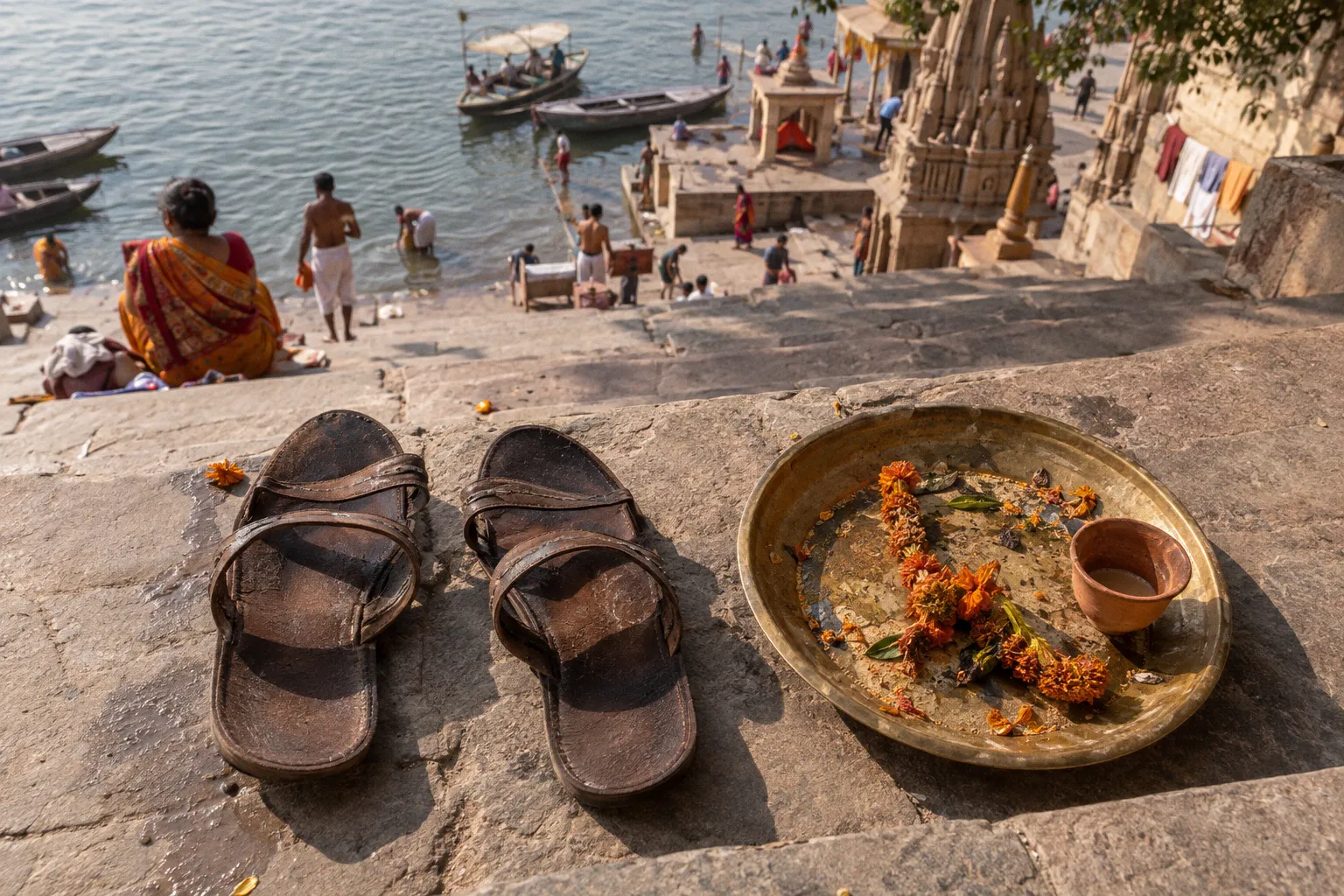
That distinction matters more than the headline number of ghats.
There are roughly 84 to 88 recognized ghats along the Ganga. You can walk a short 1-kilometer heritage corridor in 30 to 45 minutes, cover about 3 kilometers from Assi Ghat to Dashashwamedh Ghat, or attempt the full southern-to-northern stretch toward Namo Ghat and Rajghat, which runs approximately 5.9 to 6.5 kilometers depending on lane detours and access conditions.
Do not treat those routes as interchangeable. Pick the distance first. Then build the ritual stops, architecture, boat movement, heat, crowds, and restricted areas around it.
Choose the route before you choose the ghat
The most common mistake is starting at Assi Ghat with no finish point. That sounds flexible. It is not. The southern stretch is easy to underestimate, and once you reach Dashashwamedh, crowd density becomes the main bottleneck. Continue north without a plan and the route becomes slower, tighter, and less predictable.
These are the practical route options:
| Route | Approximate distance | Working time | Best use |
|---|---|---|---|
| Dashashwamedh to Manikarnika | About 1 km | 30–45 minutes | Compact heritage walk with major historic ghats |
| Assi to Dashashwamedh | About 3 km | 1.5–2.5 hours with stops | First riverfront walk and morning exploration |
| Assi to Manikarnika | About 3–4.5 km | 2–3 hours | Longer southern-to-central route |
| Assi to Namo Ghat or Rajghat | About 5.9–6.5 km | Several hours | Full riverfront survey for strong walkers |
| One section plus a boat return | Variable | Flexible | Efficient option when heat or crowding builds |
The figures describe the route, not a guaranteed uninterrupted path at the lowest river level. Monsoon conditions can submerge lower steps and interrupt shore access. Do not confuse a map line with a usable walking surface.
The optimal ghat walk is not the longest one. It is the route you can finish before heat, crowd density, and river level turn logistics into the main event.
For most travelers, the 3-kilometer Assi-to-Dashashwamedh route is the best starting point. It gives you a broad view of the riverfront without forcing you into the northern stretch when energy and attention are already dropping. If your priority is architecture and ritual density rather than distance, bypass the southern start and walk Dashashwamedh to Manikarnika instead.
The Southern Heritage Stretch: Assi to Dashashwamedh
Assi Ghat is the cleanest operational starting point for a morning route. The approach is comparatively straightforward, the riverfront is broad enough to orient yourself, and early activity gives you time to move before the central ghats tighten with visitors, vendors, priests, bathers, and boat traffic.
The southern-to-central walk covers approximately 3 kilometers. Walk it as a sequence of controlled sections rather than one uninterrupted march.
Start with Assi Ghat and the morning program
Assi is where many visitors begin with Subah-e-Banaras or the morning aarti. The schedule and format can change, so confirm locally rather than relying on an old itinerary. The key logistical point is timing: morning gives you better visibility, lower heat, and more room to inspect the riverfront without constantly negotiating around evening ceremony crowds.
Do not arrive, sit for ten minutes, and then assume the route will remain equally open. The riverfront changes quickly as activity increases. If you want a reliable walking window, begin early and use the first hour to cover the southern section.
At Assi, establish three things before moving north:
- Where the usable lower steps end and the higher walking level begins.
- Whether water has cut off any direct section along the bank.
- Which inland lane will serve as your bypass if the steps become congested.
The last point matters throughout Varanasi. The riverfront is not a straight sidewalk. Some sections are faster from the upper lane; others are worth staying on the steps for the architecture and river access. Keep both options open.
Use the middle ghats as checkpoints
Between Assi and Dashashwamedh, the route passes through a dense run of religious, residential, and historic riverfront spaces. You will encounter ghats associated with temples, regional patrons, palaces, bathing, local ceremonies, and daily riverside work. Do not attempt to study every one in equal depth. That is how a manageable walk becomes an exhausting inventory.
Instead, use physical checkpoints. Mark the major ghats you want to inspect, then keep moving between them. Chet Singh Ghat is a useful architectural stop, particularly for travelers interested in the fortified riverfront structures and the layering of palace construction along the bank. Other ghats may be more active at the hour you pass through. Treat that activity as a condition of the route, not as a promise of a fixed attraction.
The practical sequence is simple:
1. Begin at Assi before the morning crowd thickens.
2. Walk north along the upper or lower riverfront level, depending on water and congestion.
3. Pause at selected historic ghats rather than stopping at every landing.
4. Move inland when steps become blocked by ceremony setup, bathing activity, maintenance, or boat operations.
5. Rejoin the river at the next recognizable ghat.
6. Finish at Dashashwamedh before deciding whether to continue.
That last decision should be made on the spot. Dashashwamedh is not merely another waypoint. It is a crowd and ceremony bottleneck. If your route has already taken two hours, do not commit automatically to Manikarnika or Namo Ghat. You may get more from the day by taking a boat, returning through the lanes, or stopping for the evening aarti later.
When the southern route works best
Choose Assi to Dashashwamedh if you want:
- A first overview of the Ganga river ghats without covering the entire bank.
- Morning activity and a comparatively manageable start.
- A balance of riverfront architecture, bathing areas, temple approaches, and everyday movement.
- Enough distance to understand the scale of Varanasi without turning the day into a forced endurance walk.
- Flexibility to stop, bypass, or exit into the city before the central crowd becomes a bottleneck.
This is also the strongest route for travelers who want to combine walking with a later boat ride. Walk north while visibility is good, then use the river to understand the same ghats from a different angle. Do not hire a boat merely because every visitor seems to be doing it. Use it when it solves a route problem or gives you a practical return option.
The Heart of the City: Navigating the Dashashwamedh–Manikarnika Corridor
If you have limited time, start here. The walking path from Dashashwamedh to Manikarnika is approximately 1 kilometer and usually takes about 30 to 45 minutes to navigate, but the distance is deceptive. Movement speed depends on crowd density, ceremonies, boat loading, vendors, and the amount of time you spend at each ghat.
This corridor gives you one of the highest concentrations of riverfront activity and historic reference points in the city. It also demands stricter behavior. You are not walking through a museum. People are bathing, praying, working, carrying supplies, arranging rituals, and conducting funerary rites.
Dashashwamedh is a timing problem
Dashashwamedh Ghat is the operational center of many riverfront itineraries. It is also where visitors create avoidable delays. Approaches narrow. Groups stop in the middle of movement lanes. Boat operators negotiate with arriving travelers. Ceremony preparation occupies sections of the platform.
If you want to inspect Dashashwamedh rather than simply pass through, arrive outside the peak evening crush. For the Ganga Aarti, arrive with a fixed plan and enough time to secure your position without blocking working routes. After the ceremony, do not assume the exit will be immediate. The crowd dispersal creates its own bottleneck.
For walking, use the upper edge when the lower platform is occupied. Keep the river visible, but do not insist on the lowest step if it forces you into a stationary crowd. The optimal line is the one that keeps you moving while preserving access to the next ghat.
Man Mandir Ghat requires a deliberate stop
Man Mandir Ghat sits beneath the Man Mandir Palace built by Raja Man Singh around 1600, one of the more distinctive fortified riverfront structures in the city. Later, in the early 18th century, Sawai Jai Singh II constructed an observatory at this site, part of the Jantar Mantar tradition that produced similar instruments at Jaipur, Delhi, Ujjain, and Mathura. Treat the stop as architectural reading rather than a quick photo pass. Look at the relationship between the palace structures, the observatory's surviving elements, the steps, and the river approach. You do not need to turn the stop into a long lecture. Give it a few focused minutes, then clear the route.
This is where a guide can help, but do not outsource all navigation. Confirm the next physical landmark yourself. Riverfront names are easy to confuse, especially when a guide points toward a structure that is visible but not directly accessible from the level where you are standing.
Treat Manikarnika as a restricted working site
Manikarnika Ghat is a functioning cremation ground, not an attraction designed for visitor consumption. Its historical importance is inseparable from its current use. Keep distance, lower your voice, and follow instructions from people working on site.
This corridor connects the most photographed ghat in the city to the most sensitive working ghat, in roughly the distance it takes to cross a long city block. The behavioral standard does not shift gradually. It shifts at the edges of Manikarnika, and you are responsible for noticing where.
The Northern Expansion: Extending Your Walk to Namo Ghat
The northern route is where planning matters most. From Assi to Namo Ghat or Rajghat, the full riverfront stretch is approximately 5.9 to 6.5 kilometers. The difference reflects inland detours, changing access, and the fact that the usable path is not a uniform promenade.
Namo Ghat has become an important northern reference point in current riverfront planning and visitor movement. Rajghat marks the northern end of the broader route near the Varuna-Ganga area. Whether you finish at Namo Ghat, continue toward Rajghat, or exit into the city depends on water level, time, and the condition of the connecting sections.
Do not attempt the full route as a casual stroll
A 6-kilometer riverfront route is not difficult because of the number alone. It is difficult because the walk includes stops, stairs, detours, crowd negotiations, uneven surfaces, and periods when you must choose between a direct-looking river edge and a faster inland bypass.
Build the full route in stages:
- Assi to Dashashwamedh: southern heritage and morning activity.
- Dashashwamedh to Manikarnika: high-density historic core.
- Manikarnika to the northern ghats: working riverfront, palace structures, local movement, and fewer obvious tourist pauses.
- Northern approach to Namo Ghat or Rajghat: route finish, depending on access and conditions.
Use a hard turnaround time. If you start late, shorten the route. If the riverfront slows you down, exit before the next section rather than pretending the schedule will recover. Varanasi has enough complexity to punish optimistic arithmetic.
Ganga Mahal and palace structures
The northern and central riverfront include structures that reward travelers interested in built history rather than only ceremony. Ganga Mahal Ghat is associated with Narayan Palace, built in 1830. The palace-and-ghat relationship is a recurring pattern along the riverfront: patronage, residence, ritual access, and public steps are compressed into one narrow edge.
Do not judge a ghat only by its open platform. Look upward. The riverfront architecture often makes more sense from the lower steps, where you can see how buildings were designed to face the water, but the upper lanes reveal how those structures connect to the current city. If lower access is blocked or submerged, use the upper route and inspect the facade from there.
This is also where the walking route becomes less useful as a single tourist product. Some sections are better understood by combining a short walk with a boat view. A boat can reveal the scale and alignment of the ghats; walking shows the working details, stair connections, shrines, walls, and lane entries that are invisible from the water.
Logistics of the Riverfront: Seasonal Accessibility and Monsoon Constraints
The Ganga changes the usable route. Water levels alter the width of steps, the location of boat landings, and the possibility of walking along lower platforms. During high monsoon conditions, sections that are normally passable can be submerged or interrupted. The exact step count and continuous walkability of the full stretch cannot be treated as fixed.
This is the point where many route descriptions become unreliable. They measure a dry-season line and present it as a permanent pedestrian path. Do not plan that way.
Before starting, ask a local boat operator, hotel staff member, guide, or ghat worker one direct question: which sections are currently passable along the river edge, and where should you use the upper lane? Avoid vague questions about whether the route is generally open. You need a current access read, not a tourist-brochure answer.
The seasonal pattern is consistent enough to plan around, even when exact conditions vary year to year:
- Winter (roughly October to February): lowest water, widest usable step surface, best conditions for a continuous lower-riverfront walk. Crowds are heaviest around major festivals.
- Summer (roughly March to June): workable but punishing by mid-morning. Heat forces earlier starts or a boat-based approach.
- Monsoon (roughly July to September): higher water, fewer usable lower steps, intermittent submergence of connecting sections. Inland bypasses become the default route for long stretches.
Treat any pre-monsoon published walking distance as an estimate. The same route in late July may force you onto upper lanes for half its length, which adds climbing and removes the direct riverfront view.
Plan around the river, not against it. The walking route options are real, but they are real in the sense of being workable sequences of steps, lanes, and bypasses, not real in the sense of a fixed pedestrian path. Anyone who sells you the ghats as a continuous boardwalk is selling a different Varanasi than the one you will walk.
Cultural Etiquette and Photography Boundaries at Cremation Sites
The rules at Varanasi's cremation ghats are not etiquette suggestions. They are operational boundaries around a working funerary site, and they apply regardless of your camera, your guide's reassurance, or your distance from the pyres.
Photography is strictly prohibited at cremation ghats, including Manikarnika and Harishchandra. This covers phones, dedicated cameras, and video. Do not negotiate around that boundary. Do not use a phone discreetly. Do not photograph from a boat and assume distance changes the rule. It does not.
The correct route behavior is straightforward:
- Stop outside active working areas unless local staff or family members direct otherwise.
- Keep cameras and phones away.
- Do not block the movement of wood, bodies, mourners, or workers.
- Do not ask intrusive questions during a funeral.
- Do not turn cremation activity into a visual checklist.
You can understand the ghat's role without collecting images. That is not a limitation of the visit. It is the minimum standard for entering a living funerary space.
The same restraint applies beyond photography. Keep your voice low. Move steadily rather than lingering. Treat mourners and workers as the primary users of the space. If a family member is grieving on the steps, the correct path is the wider one, not the shortest one. The riverfront remains a public space, but the public it serves at a cremation ghat is not you.
Dress with that in mind as well. Modest covering of shoulders and legs is the practical baseline on any section of the riverfront, and it is not negotiable at the cremation corridor. Travelers who arrive in shorts and tank tops are not breaking a tourist rule; they are inserting themselves into a setting that does not accommodate that clothing.
The ghats do not belong to the visitor. The walking route is borrowed space, and the parts that look most dramatic are the parts with the strictest rules.
The wider etiquette standard is simpler than the photography debate suggests. Walk as if the riverfront were a working hospital corridor. Move purposefully, speak quietly, do not stop where stopping causes congestion, and accept that certain sections are not for you to evaluate, photograph, or rank.
Final word
Varanasi's riverfront rewards travelers who treat the walk as logistics first and sightseeing second. Choose the route that matches your time, your heat tolerance, and your willingness to share space with working pilgrims, bathers, and mourners. Confirm access on the day. Use the upper lanes without guilt when the steps fail. And remember that the longest possible walk is not the point. The point is to finish the route you started, with attention intact, before the river, the crowd, and the clock close it down.